This course introduces learners to technologies that will help in:
1) Creating GIS maps
2) Using satellite & drone imagery to enhance these GIS maps
3) Analysing changes in satellite & drone imagery over space and time using AI/ML algorithms
4) Developing GIS apps using Full Stack Technologies: NodeJS/React/Leaflet
5) Modelling real-world problems and potential solutions using the System Dynamics tools
Live Sessions :
On all Wednesdays & Saturdays: 07:00 p.m. - 08:00 p.m.
Every week:
Self-paced
Profile of the Instructor(s)
Nagesh Kolagani is a Professor of Computer Science and Engineering at Centurion University of Technology & Management (CUTM), Vizianagaram, AP. He is an alumnus of IIT Madras: B.Tech. (1988), Ph.D. (2016). He has 25+ years of experience in developing IT/GIS solutions for industry, Government, and village stakeholders. He worked earlier as a Software Engineer at Borland Corporation (CA, USA), Project Scientist at IIT Madras, Associate Professor at IIIT Sri City (AP), Head GIS at TN e-Governance Agency, etc.
Abhijit P. Deshpande is a Professor of Chemical Engineering and co-PI of Rural Technology Action Group (RuTAG) at IIT Madras. He coordinated activities of RuTAG from 2018 to 2024. Among the technologies developed during this period are paddy thresher, automatic coir spinning machine, groundnut pod separator, madurkathi handloom mat weaving using electronic jacquard, vending cart, frugal hearing aid and mango seed decorticator. A fabrication/design platform that aims to enable local fabrication is also being developed.
Module Details
MODULE - 1 : GIS Maps
Concepts Covered:
Introduction to GIS - Practice videos of QGIS
Learning Outcomes:
You will be able to create GIS maps using QGIS
MODULE - 2 : Satellite Imagery
Concepts Covered:
Introduction to Remote Sensing using satellite imagery - Practice videos of Google Earth Pro
Learning Outcomes:
You will be able to create GIS maps using Google Earth images as background
MODULE - 3 : Drone Imagery
Concepts Covered:
Introduction to Remote Sensing using drone imagery - Practice videos of WebODM and QGIS
Learning Outcomes:
You will be able to create ortho-mosaiced and annotated drone images and use them as background to create GIS maps
Machine Learning, Spatio-Temporal Analysis, Satellite Imagery - Practice videos with Google Earth Engine
Learning Outcomes:
You will be able to carry out spatio-temporal analysis using Google Earth Engine, JavaScript & ML algorithms
MODULE - 6 & 7 : Machine Learning & Drone Imagery
Concepts Covered:
Machine Learning, Spatio-Temporal Analysis, Drone Imagery - Practice videos with Google Colab
Learning Outcomes:
You will be able to carry out spatio-temporal analysis using Google Colab, Python & ML algorithms
MODULE - 8 : Participatory Modelling
Concepts Covered:
Causal Loop Diagrams
Learning Outcomes:
You will be able to model & simulate socio-economic systems & others using System Dynamics
MODULE - 9 : Participatory Modelling
Concepts Covered:
Stock and Flow Diagrams
Learning Outcomes:
You will be able to model & simulate socio-economic systems & others using System Dynamics
Note: Learners not interested in “Mobile & Web GIS App Development” during the last three weeks 10, 11 and 12 can alternatively work on an intensive “GIS-based Participatory Modelling Project” and submit it as 3 parts during those three weeks.
MODULE - 10 : Mobile & Web GIS App Development
Concepts Covered:
HTML, CSS, JavaScript
Learning Outcomes:
You will be able to create basic web user interfaces
MODULE - 11 : Mobile & Web GIS App Development
Concepts Covered:
NodeJS
Learning Outcomes:
You will be able to create server side of a mobile &/or web GIS app
MODULE - 12 : Mobile & Web GIS App Development
Concepts Covered:
React & Leaflet
Learning Outcomes:
You will be able to create client side of a mobile &/or web GIS app
Detailed plan
This course will start on the 02nd of Feb, 2026, and will run for twelve weeks, until the 26th of April, 2026. Each week, the learners will:
1) Watch about 3 videos, each about 20 minutes
2) Submit weekly assignments and course projects
3) Attend and participate in 1-hour live sessions on Wednesdays and Saturdays every week
Note: Learners not interested in “Mobile & Web GIS App Development” during the last three weeks 10, 11 and 12 can alternatively work on an intensive “GIS-based Participatory Modelling Project” and submit it as 3 parts during those three weeks.
Fees for the Workshop
NGO : Rs 2,360 (Rs 2,000 + 18% GST)
Students :
General - Rs 2,360 (Rs 2,000 + 18% GST)
CUTM Students - Rs 118 (Rs 100 + 18% GST)
Faculty : Rs 2360 (Rs 2,000 + 18% GST)
Government Organization : Rs 8850 (Rs 7,500 + 18% GST)
Industry : Rs 8850 (Rs 7,500 + 18% GST)
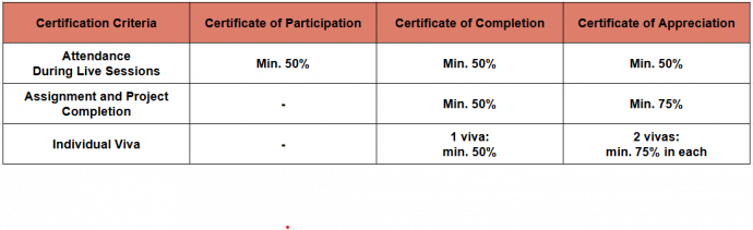
Certification
The criteria for the certificate is as follows:
Attendance During Live Sessions
Assignment Demonstration During Demo Live Sessions
Assignment and Project Completion
Feedbacks from Previous Learners
The course allowed knowing about the latest tools in GIS and spatial data analysis, and learn the concepts with a hands-on approach
The students gained valuable insights into the practical aspects of Spatial data, especially Drone imaging and analysis
The course videos and the steps were sufficient to cover the topic and to perform the task. The live sessions were adequate to explain the concepts and give demos.
We were fortunate to have professor Kolagani as a faculty for the course who guided us throughout with lot of patience.
Live sessions are very well handled by the faculty. He explains everything from scratch and helps us solve assignments
Targeted Audience
NGO
Students
CUTM students
Faculty
Government
Industry
2 reviews for GIS, Drones & Machine Learning for Resource Mapping & Analysis – Batch 4
Rated 5 out of 5
Dr. K. Ravikumar (verified owner)–
Feedback:
1. I like the topics of the workshop covering wide range of topics, upto 7th week, from GIS basics, Drones Imagery, Satellite imagery and their classification using ML etc. and 9th to 12 week, HTML basics, GIS to WebGIS are given basic knowledge. With this fundamentals, i can go into depth of their applications in my field of research.
2. Instructor, Nagesh sir has spent his time 2 hours every week without fail and trained online in softwares, experienced a handheld training.
3. Video durations are short and crisp. It is very easy for learners to grab in bits and understand topics effortlessly.
Points for improvement:
1. Quality of video material can be improved.
2. Gradings can be awarded weekly so that a participant can assess his performance weekly and helps in upcoming weeks to avoid low scoring.
3. Like NPTEL, assignment submission time can be extended to 10 days instead of 7 days.
Rated 5 out of 5
C. Vijayakumaran (verified owner)–
The 3 things I liked in the course:
1. The course integrates full-stack development with GIS, which bridges the gap b/w Drone Data Acquisition, Geospatial Analysis and data classification using ML
2. The course specifically provides practical training on QGIS, WebODM, Python, React, etc.
3. Moreover, it mainly focuses on real-world applications such as water body mapping, vegetation analysis and plantation causality detection, which are essential for researchers to create useful projects in this field.
The 3 ways it can be further improved:
1. It may include Big Data concepts to handle terabytes of imagery data
2. It may include some more features of Drone Technology
3. Also, how the Digital Twin concepts fit for this type of analysis
Your support and enthusiasm rendered towards the successful completion of the course are remarkable and unforgettable. Thanking you.


Dr. K. Ravikumar (verified owner) –
Feedback:
1. I like the topics of the workshop covering wide range of topics, upto 7th week, from GIS basics, Drones Imagery, Satellite imagery and their classification using ML etc. and 9th to 12 week, HTML basics, GIS to WebGIS are given basic knowledge. With this fundamentals, i can go into depth of their applications in my field of research.
2. Instructor, Nagesh sir has spent his time 2 hours every week without fail and trained online in softwares, experienced a handheld training.
3. Video durations are short and crisp. It is very easy for learners to grab in bits and understand topics effortlessly.
Points for improvement:
1. Quality of video material can be improved.
2. Gradings can be awarded weekly so that a participant can assess his performance weekly and helps in upcoming weeks to avoid low scoring.
3. Like NPTEL, assignment submission time can be extended to 10 days instead of 7 days.
C. Vijayakumaran (verified owner) –
The 3 things I liked in the course:
1. The course integrates full-stack development with GIS, which bridges the gap b/w Drone Data Acquisition, Geospatial Analysis and data classification using ML
2. The course specifically provides practical training on QGIS, WebODM, Python, React, etc.
3. Moreover, it mainly focuses on real-world applications such as water body mapping, vegetation analysis and plantation causality detection, which are essential for researchers to create useful projects in this field.
The 3 ways it can be further improved:
1. It may include Big Data concepts to handle terabytes of imagery data
2. It may include some more features of Drone Technology
3. Also, how the Digital Twin concepts fit for this type of analysis
Your support and enthusiasm rendered towards the successful completion of the course are remarkable and unforgettable. Thanking you.